Overview
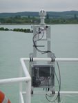
The HSP1 measures the spectrum of downwelling solar radiation, and how this is partitioned between Direct, Diffuse and Global Irradiance. This sensor provides a reference for the colour or spectral distribution of sunlight near the water's surface.
HSP1 can be used to improve the accuracy of other sensors making direct measurements of the reflected light from the water body.
Apply HSP1 data
- Measurements can be used to improve satellite water quality products by removing or correcting for atmospheric effects, especially in coastal or inland waters.
- Improving data products from other surface-based instruments (such as other MONOCLE instruments) where a reference is normally too expensive
- In situations where existing equipment is difficult or impossible to use such as moving platforms, boats, buoys or aircraft.
The sensor uses a spectrometer to measure the incident downwelling solar irradiance in the 350nm – 1050nm range, of Global, Direct and Diffuse horizontal irradiance.
Derived quantities such as AOD, Water column depth.
Supporting measurements of time, position, orientation, temperature, pressure and humidity can also be made.
A combination of a horizontal array of detectors under a complex shading pattern enables a measurement of Global Direct and Diffuse irradiance with no moving parts or polar alignment requirements. This makes the instrument cheaper and easier to use than conventional instruments which rely on sun-tracking robots.

Mounted on fixed mast, or on boat, buoy, or aircraft
We provide several interoperable data interfaces, as detailed below:
Type of data: Hyperspectral global and diffuse irradiance data
Format: WMS, WFS (calibrated and calculated products)
Geoserver
(Layers: search for ‘hsp’)
- rsg:hsp_public_view_short (spectrally integrated data only)
- rsg:hsp_public_view_full (full spectral dataset)
- rsg:hsp_public_view_deployments (overview of system activity)
WMS GetCapabilities
WFS GetCapabilities
Sensor activity and data dashboard
Supporting materials
Video:
So-Rad and HSP1 introduction and installation on MV Armorique
User guide:
HSP1 Quickstart guide
Download the operational protocols for MONOCLE sensors and platforms This document provides a set of protocols for
the deployment of MONOCLE systems to ensure best practices to collect reliable data.
System user and developer handbook This handbook provides an overview of the data requirements and interfaces that were adopted in the sensors and observation platforms of MONOCLE.
The data below shows recent sensor deployment activity. Access more detail and explore other sensor deployment activity on the MONOCLE dashboard .
Jordan, T.M., Simis, S.G.H., Grötsch, P.M.M. and Wood, J.
Incorporating a Hyperspectral Direct-Diffuse Pyranometer in an Above-Water Reflectance Algorithm
Remote Sens. 2022, 14(10). https://doi.org/10.3390/rs14102491
Autonomous marine hyperspectral radiometers for determining solar irradiances and aerosol optical properties (2017). John Wood et al. Atmos. Meas. Tech., 10, 1723–1737, 2017 doi: 10.5194/amt-10-1723-2017