Overview
The WISPstation is a high-end, affordable, extremely low power optical instrument to measure water-leaving reflectance from buoys and at fixed locations. Without any moving parts, it is still able to reliably capture the water leaving reflectance during the biggest part of the day. It uses two sets of sensors in a carefully chosen configuration to measure the light reflecting from the water for the full visible and near-infrared spectral range. The reflectance observations are used to validate satellite measurements of water-leaving reflectance produced by various ‘atmospheric correction’ models.
From the reflectance it determines the concentrations of the most important bio-physical water quality parameters such as chlorophyll, cyanobacterial pigment, suspended matter, the presence of scums and transparency.
The WISPstation sends the measurements automatically over 3G or 4G to WISPcloud, which processes the measurements, applies a first quality check and makes the results available via an API. Measurement frequency is easily adjusted to suite the user’s requirements (
Peters et al., 2018)
Click here for more detailed information about the WISP station and other WISP products.
Added value of the WISPstation for water managers
Traditional forms of monitoring water quality, especially for harmful algae blooms, are limited spatially and temporally as well as by the time it takes to process the collected water samples. Optical measurements provide a new and innovative solution for effective monitoring of surface water quality.
The ability to measure water quality parameters as a high frequency time-series at a fixed location makes the instrument very suitable for routine unattended monitoring and as input to data-driven (machine learning) prediction models.
The WISPstation measures the main water quality parameters fully autonomously, in a high frequency (e.g. every 15 minutes), emission-free and without any chemicals, and makes the results available near-real-time, directly visible within the systems of clients, and/or with immediate warnings to the public.
In MONOCLE a very reliable low power consumption solution was realized. A semi-portable version is under development.
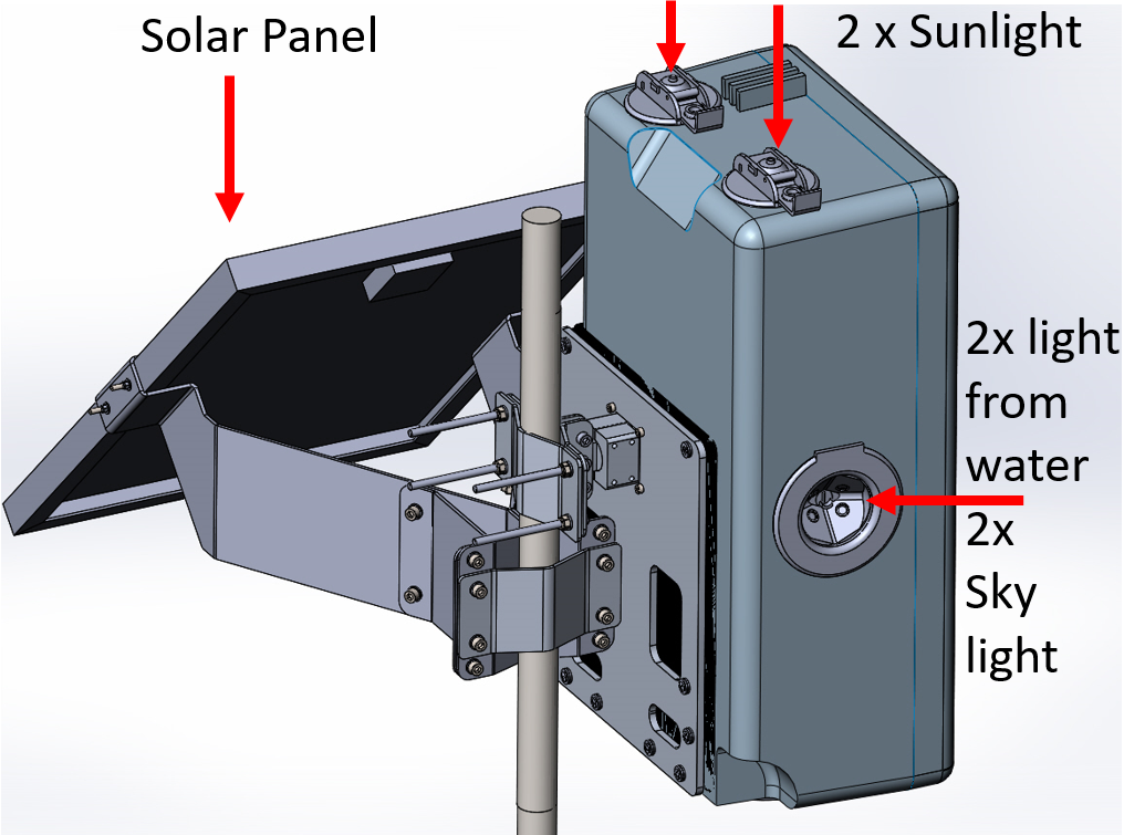
- The instrument measures hyperspectral downwelling irradiance (2 channels), downwelling sky radiance (2 channels) and upwelling water leaving radiance (2 channels)
- Per channel 10 subsequent measurements are taken for quality control and to identify outliers
- The instrument can be programmed to synchronise to the exact overpass time of interesting satellites and a time window around that, thus greatly enhancing the probability of obtaining a match-up measurement.
- Because of the absence of moving parts, the complete measurement cycle takes place within a very small time frame which means that the measurement is hardly affected by changing light conditions
- Due to its configurability, the WISPstation can utilize the newest spectrometer developments, currently we offer a highly sensitive system at a spectral resolution of 0.42 nm or 4.65 at FWHM which is a 2-3-fold improvement to e.g. TRIOS systems.
- The design makes the instrument insensitive to radiometric calibration drift of the spectrometer.
- Reflectance measurements are used to automatically derive water quality parameters such as: Chlorophyll-a, Suspended matter, Phycocyanin and Transparency (Kd) which are indicators for primary production, eutrophication, cyanobacteria development and water clarity
Measures light leaving from the water as a ratio of the incoming light for the full visible and near-infrared light spectrum. To do this it measures in two directions the light leaving the water (Lu), and two directions the light coming from the sky (Lsky). Depending on the time of the day and therefore the position of the sun, it uses the set with the least direct sun reflection on the surface.
The WISPstation automatically measures at certain intervals (e.g. every 15 minutes, during daytime) and sends its measurements to WISPcloud where the calibration is applied, quality control is performed and concentrations of water quality parameters are calculated.
Feedback from stakeholders
EOMORES User Workshop: Jannes Schenkel from Noorderzijlvest on the benefits of EOMORES. Includes discussion of how WISPStation would used.
Watch video on YouTube.

c82e.jpg?maxsidesize=150)
Technical drawing

Diagram of WISPstation
- Attached to a pole or on a platform, above the water surface.
- Preferably face North (on the Northern hemisphere) or South (on the Southern hemisphere), to avoid facing directly into the sun or sun glint on the water.
- Requires free view on open water without floating items or bottom visibility.
We provide several interoperable data interfaces, as detailed below:
Type of data: Hyperspectral reflectance and derived variables
Format: Proprietary API (Manual available: On WISPcloud website)
Data from Lake Balaton
Data from Lake Tanganyika
Access information
Username: public_access
Password: WISPstation
Download the operational protocols for MONOCLE sensors and platforms
This document provides a set of protocols for
the deployment of MONOCLE systems to ensure best practices to collect reliable data.
System user and developer handbook This handbook provides an overview of the data requirements and interfaces that were adopted in the sensors and observation platforms of MONOCLE.
http://www.waterinsight.nl/info/wispstation-fixed-position-autonomous-water-quality-spectrometer
Examples of sensor use
WISPStation was part of EMORESE project, related documents:
EOMORES deliverable with some feedback from users/partners
Validation report of EOMORES, including the validation results of the WISPstation
The data below shows recent sensor deployment activity. Access more detail and explore other sensor deployment activity on the MONOCLE dashboard .